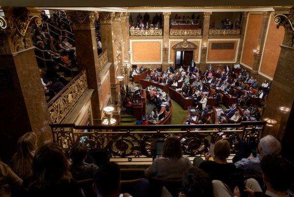
We’re in the final hours of Utah’s redistricting process. The process was already rushed this year, thanks to COVID and delays in getting 2020 census data, but the Utah State Legislature still has to vote on the new boundaries in time to have them in place by the beginning of 2022. One of the last chance Utah voters had to potentially impact what those boundaries look like was at a public hearing at the Utah State Capitol on Nov. 10, but the meeting was cancelled. So, what now? While this is about to get a little wonky, if you want your vote to count for as much as your neighbor’s in another district, this should matter to you. After the Legislature decides on new boundaries, we’re stuck with what we get for another 10 years.
This year—two groups engaged in simultaneous, but mostly separate, redistricting efforts. Both groups held public hearings and called on Utah citizens to draw and submit their ideas for possible boundary maps. Both groups made their own maps and met to decide which maps provide the best representation for Utah’s burgeoning population. But only one group has the authority on which potential boundary maps are put up to the legislature for final approval. In the end, the other group’s maps might not even get a vote.
So, why have two redistricting groups at all? Because a majority of Utah voters wanted it that way (by about 7,000 votes). Flashback to 2018. The group Better Boundaries put forth Proposition 4, which would create the Utah Independent Redistricting Commission to draw up electoral boundary maps and recommend them to the Legislature. The Legislature could then vote on whether to approve or reject those maps. The intention was that an independent commission would not be drawing the boundaries of their own districts, as legislators would, and, therefore would not have conflicts of interest or incentive to gerrymander. “It centers redistricting on voters versus centering it on politicians,” Better Boundaries executive director Katie Wright says of the independent commission. “Better Boundaries believes that voters should be choosing their politicians, not politicians choosing their voters.”

When Is It Gerrymandering?
Gerrymandering is when district boundaries are drawn to favor one party, which has the effect of making elections less competitive and disenfranchising other voter groups. It can be almost impossible to prove when lines have been intentionally gerrymandered. While there is some debate over whether or not Utah boundaries are gerrymandered, in 2010, the GOP-controlled Legislature drew lines in such a way to break up Salt Lake County, a democratic stronghold, among three congressional districts.
But, here’s the thing. Lawmakers are still drawing maps of their own districts. After the proposition passed, lawmakers threatened to repeal the initiative altogether, so Better Boundaries came to the table to negotiate. The 2020 compromise, Senate Bill 200, rolls back some of the initiative’s original redistricting reforms passed by voters. It removes the requirement that the Legislature vote on the commission’s proposals and follow specific redistricting criteria and gets rid of the right of private citizen lawsuits if the Legislature approves maps different than the commission’s recommendations.
The Legislative Redistricting Committee is the other group that’s drawing possible electoral boundary maps, but the group of 20 lawmakers (15 Republicans and five Democrats) is not adhering to the same map-drawing standards as the Utah Independent Redistricting Commission pro by Better Boundaries.
The law outlines some redistricting standards. Like all states, Utah must comply with constitutional equal population requirements—just how equal in population districts have to be seems to vary state to state. In addition to this tenuous legal requirement, the self-imposed principles adopted by the Legislative Redistricting Committee include:
- Districts must be contiguous and reasonably compact.
- State legislative districts and state school board districts must have substantial equality of population among the various districts, with a deviation less than ±5.0%.
- Congressional districts must be as nearly equal as practicable, with a deviation no greater than ±0.1%.
When drawing electoral districts, the independent commission considers population distribution as well as the three Cs: keeping cities and counties and communities of interest intact—these are localized communities that share economic and cultural interests (allowing voters with aligning interests to form an informal coalition). The commission also does not take into consideration political party data or where incumbents live (if a lawmaker gets drawn out of their current district, so be it). The Legislative Redistricting Committee’s criteria does not forbid including incumbent data, which, as Better Boundaries has pointed out, could be considered a conflict of interest. In theory, lawmakers could draw boundaries to make their own seats safer or to punish political opponents.
But, if that does happen, how do you prove it? And even if you can prove it, the only recourse is voters giving a damn and voting that representative out. Which could be made all the more difficult if their district’s boundaries have already been redrawn in that elected official’s favor. In order for any of this to work, it requires people to (again for emphasis) give a damn, get involved and hold their elected officials accountable. “Redistricting is an issue so fundamental to our democracy and how citizens interact with their government,” says Wright. “It is a lot. And it is very confusing, complex and a bit wonky, but redistricting determines with whom you’re united within your representation.”
On Monday, the Independent Redistricting Commission presented its recommended maps to the Legislative Redistricting Committee. Now the committee will choose which maps—from those drawn by the committee, the commission or the public—to recommend to the full Legislature. But the process has not been without drama. Some members of the Legislature have done a considerable amount of marking their territory when it comes to redistricting. Utah voters may have chosen to create the independent commission, but the opinion of some lawmakers seems to be that it doesn’t matter what the majority of voters wanted.
Better Boundaries believes that voters should be choosing their politicians, not politicians choosing their voters.
Katie Wright, Better Boundaries
When they presented the maps to the legislative committee, the independent commission detailed the process of how they arrived at their maps. Of course, this comes after its commissioner, Rob Bishop, abruptly resigned from the commission—in supposed opposition to its map drawing process—during one of its final meetings. He accused the committee of gerrymandering in favor of Democrats by being too “metro-centric.” Never mind the fact that most of Utah’s population lives in metro areas. Likely, what he’s really concerned about is any map where Salt Lake County residents have enough consolidated voting power in a single district to vote in a Democrat to congress.
“I share his [Bishop’s] frustrations with how the commission has conducted its business. His decision to step down at this point in the process is further evidence that the duly elected representatives of the people are best suited to redraw district boundaries,” said Utah House Speaker Brad Wilson in a statement immediately following Bishop’s resignation. It’s worth noting that Wilson is also the one who appointed Bishop as commissioner in the first place, so the grandstanding and political theater, meant to cast doubt on the commission, smells faintly of contrivance.
The legislative committee is set to select the final maps in an upcoming interim legislative session, sometime mid-November. Then the maps are approved by the full Legislature and go to the Governor for final approval by December. Even though the legislative committee has full discretion here, the independent commission’s maps could still serve a purpose. Voters can inspect how the commission’s recommended maps differ from what the legislature adopts, providing some level of transparency and, potentially, the opportunity to hold our representatives accountable.
You can see the boundary maps presented by Independent Redistricting Commission in its final report, available for download on their website. You can also view and comment on maps considered by the Legislative Redistricting Committee on its website. This story first appeared in the November/December print issue of Salt Lake magazine. Subscribe for more.